Geolocate

Chandannath topographic map

Click on the map to display elevation.

About this map

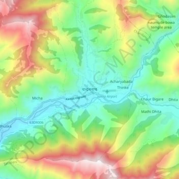
Name: Chandannath topographic map, elevation, terrain.

Location: Chandannath, Jumla, Karnali Province, 21200, Nepal (29.23495 82.14327 29.31495 82.22327)

Average elevation: 2,749 m

Minimum elevation: 2,283 m

Maximum elevation: 3,550 m

Other topographic maps

Click on a map to view its topography, its elevation and its terrain.

Chandannath

Nepal > Karnali Province > Jumla

Average elevation: 3,053 m

Hima Rural Municipality

Nepal > Karnali Province > Jumla

Average elevation: 2,824 m

tali rana

Nepal > Karnali Province > Jumla

Average elevation: 2,687 m

Gear up for your next adventure:

💡LED Camping Lantern - Illuminate your campsite with long-lasting lanterns
🧥Waterproof Pants - Keep dry during rainy hiking conditions
🥾Hiking Leggings - Comfortable leggings for outdoor activities
🥾All-Terrain Hiking Boots - Versatile boots for varied hiking conditions
🥾Hiking Shoes - Durable and comfortable shoes for trail hiking

As an Amazon Associate, this site earns from qualifying purchases at no extra cost to you.