Geolocate

Ostritz topographic map

Click on the map to display elevation.

About this map

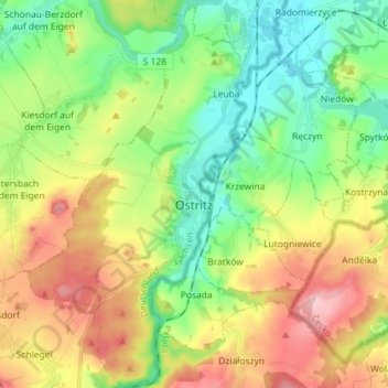
Name: Ostritz topographic map, elevation, terrain.

Location: Ostritz, Görlitz, Saxony, 02899, Germany (50.97228 14.87145 51.06236 14.96482)

Average elevation: 267 m

Minimum elevation: 192 m

Maximum elevation: 383 m

Other topographic maps

Click on a map to view its topography, its elevation and its terrain.

Rohne - Rowno

Germany > Saxony > Görlitz

Average elevation: 127 m

Elster

Germany > Saxony > Görlitz > Zittau

Average elevation: 448 m

Schlauroth

Germany > Saxony > Görlitz > Görlitz

Average elevation: 240 m

Mamut

Germany > Saxony > Görlitz > Jonsdorf

Average elevation: 519 m

Bruder Klaus

Germany > Saxony > Görlitz > Jonsdorf

Average elevation: 523 m

Rosenbach

Germany > Saxony > Görlitz > Rosenbach > Rosenbach

Average elevation: 290 m

Gear up for your next adventure:

🧥Waterproof Jacket - Lightweight rain jackets for hiking and outdoor activities
🧥Ultralight Puffy Jacket - Maximum warmth that packs down to the size of an orange
🔋Emergency Crank Radio - Weather alerts and power without needing batteries
🥾Waterproof Hiking Shoes - Durable shoes for wet and rugged trails
🥾Hiking Boots - Sturdy boots providing ankle support and traction on rugged trails

As an Amazon Associate, this site earns from qualifying purchases at no extra cost to you.