
Make a donation
Gear up for your next adventure:
As an Amazon Associate, this site earns from qualifying purchases at no extra cost to you.
Cameron topographic map
Click on the map to display elevation.
Make a donation
Gear up for your next adventure:
As an Amazon Associate, this site earns from qualifying purchases at no extra cost to you.
Cameron
Cameron is located in south-central Cameron Parish along the Gulf of Mexico at an elevation of 4 feet (1.2 m) above sea level. State highways 27 and 82 pass through the community as Marshall Street, crossing the Calcasieu Ship Channel just west of town. Highway 82 leads east 93 miles (150 km) to Abbeville and west 48 miles (77 km) to Port Arthur, Texas. Highway 27 leads west then north 48 miles (77 km) to Sulphur. Lake Charles is 52 miles (84 km) to the north.
Make a donation
Gear up for your next adventure:
As an Amazon Associate, this site earns from qualifying purchases at no extra cost to you.
About this map
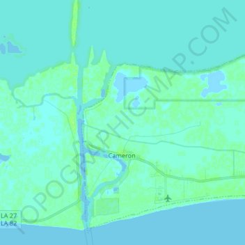
Name: Cameron topographic map, elevation, terrain.
Location: Cameron, Cameron Parish, Louisiana, 70631, United States (29.76080 -93.34742 29.86469 -93.21477)
Average elevation: 2 m
Minimum elevation: -4 m
Maximum elevation: 8 m
Make a donation
Gear up for your next adventure:
As an Amazon Associate, this site earns from qualifying purchases at no extra cost to you.
Other topographic maps
Click on a map to view its topography, its elevation and its terrain.