
Make a donation
Gear up for your next adventure:
As an Amazon Associate, this site earns from qualifying purchases at no extra cost to you.
Lacaze topographic map
Click on the map to display elevation.
Make a donation
Gear up for your next adventure:
As an Amazon Associate, this site earns from qualifying purchases at no extra cost to you.
About this map
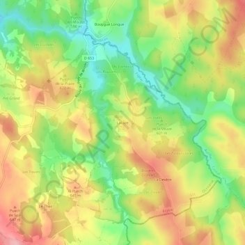
Name: Lacaze topographic map, elevation, terrain.
Average elevation: 605 m
Minimum elevation: 535 m
Maximum elevation: 675 m
Make a donation
Gear up for your next adventure:
As an Amazon Associate, this site earns from qualifying purchases at no extra cost to you.
Other topographic maps
Click on a map to view its topography, its elevation and its terrain.
Comiac
France > Occitanie > Lot > Sousceyrac-en-Quercy
Comiac, une des cinq communes du canton de Sousceyrac, avec ses quelque 40 hameaux, est installée à une altitude moyenne de 500 mètres. La sculpture dite du Dieu au Maillet, trouvée en remploi dans le portail du presbytère aujourd'hui détruit (cf. plus bas le chapitre Lieux et Monuments) atteste une…
Average elevation: 504 m
Make a donation
Gear up for your next adventure:
As an Amazon Associate, this site earns from qualifying purchases at no extra cost to you.