
Make a donation
Gear up for your next adventure:
As an Amazon Associate, this site earns from qualifying purchases at no extra cost to you.
La Verrie topographic map
Click on the map to display elevation.
Make a donation
Gear up for your next adventure:
As an Amazon Associate, this site earns from qualifying purchases at no extra cost to you.
La Verrie
Le territoire municipal de La Verrie s'étend sur 4 319 hectares. L'altitude moyenne de la commune est de 145 mètres, avec des niveaux fluctuant entre 57 et 213 mètres.
Make a donation
Gear up for your next adventure:
As an Amazon Associate, this site earns from qualifying purchases at no extra cost to you.
About this map
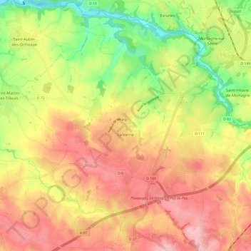
Name: La Verrie topographic map, elevation, terrain.
Average elevation: 143 m
Minimum elevation: 53 m
Maximum elevation: 215 m
Make a donation
Gear up for your next adventure:
As an Amazon Associate, this site earns from qualifying purchases at no extra cost to you.
Other topographic maps
Click on a map to view its topography, its elevation and its terrain.
Le Pont
France > Pays de la Loire > Vendée > Chanverrie > La Verrie > La Touche
Average elevation: 112 m
La Boutinardière
France > Pays de la Loire > Vendée > Chanverrie > Chambretaud
Average elevation: 200 m
Make a donation
Gear up for your next adventure:
As an Amazon Associate, this site earns from qualifying purchases at no extra cost to you.
La Perce-Pierre
France > Pays de la Loire > Vendée > Chanverrie > Chambretaud
Average elevation: 200 m
Make a donation
Gear up for your next adventure:
As an Amazon Associate, this site earns from qualifying purchases at no extra cost to you.
Le Coudreau
France > Pays de la Loire > Vendée > Chanverrie > La Verrie > Le Coudreau
Average elevation: 145 m
La Tannerie
France > Pays de la Loire > Vendée > Chanverrie > Chambretaud > La Tannerie
Average elevation: 191 m
Make a donation
Gear up for your next adventure:
As an Amazon Associate, this site earns from qualifying purchases at no extra cost to you.
Le Coteau
France > Pays de la Loire > Vendée > Chanverrie > La Verrie > Le Coteau
Average elevation: 153 m