
Make a donation
Gear up for your next adventure:
As an Amazon Associate, this site earns from qualifying purchases at no extra cost to you.
Lacs d'Ayous topographic map
Click on the map to display elevation.
Make a donation
Gear up for your next adventure:
As an Amazon Associate, this site earns from qualifying purchases at no extra cost to you.
About this map
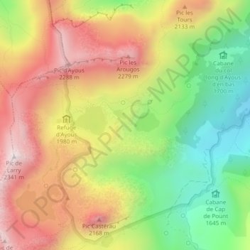
Name: Lacs d'Ayous topographic map, elevation, terrain.
Average elevation: 1,934 m
Minimum elevation: 1,550 m
Maximum elevation: 2,319 m
Make a donation
Gear up for your next adventure:
As an Amazon Associate, this site earns from qualifying purchases at no extra cost to you.
Other topographic maps
Click on a map to view its topography, its elevation and its terrain.
Le Gave du Brousset
France > Nouvelle-Aquitaine > Pyrénées-Atlantiques > Laruns
Average elevation: 1,377 m
Lac du Clot des Espagnols
France > Nouvelle-Aquitaine > Pyrénées-Atlantiques > Laruns
Average elevation: 2,164 m
Lac Bersau
France > Nouvelle-Aquitaine > Pyrénées-Atlantiques > Laruns
Le lac Bersau est un lac de la vallée d'Ossau qui fait partie des lacs d'Ayous, au pied du pic Casterau (2 227 m). Il se situe à 2 080 m d'altitude et sa profondeur maximale est de 30 m.
Average elevation: 2,045 m
Make a donation
Gear up for your next adventure:
As an Amazon Associate, this site earns from qualifying purchases at no extra cost to you.