Geolocate

Lower Yubeng topographic map

Click on the map to display elevation.

About this map

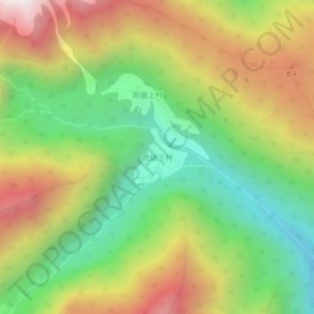
Name: Lower Yubeng topographic map, elevation, terrain.

Location: Lower Yubeng, Dêqên County, Diqing, Yunnan, China (28.37261 98.77272 28.41261 98.81272)

Average elevation: 3,505 m

Minimum elevation: 2,839 m

Maximum elevation: 4,358 m

Other topographic maps

Click on a map to view its topography, its elevation and its terrain.

Yangla

China > Yunnan > Dêqên County

Average elevation: 3,798 m

Gear up for your next adventure:

🧰Survival Kit - Essential gear for emergencies in the wilderness
🚲Heavy Duty Bike Lock - Secure your bike at the trailhead or during stops
🛶Canoe Life Vest - Safety vest for water sports
🐕Hiking Dog Pack - Let your canine companion carry their own water and food
🥾Waterproof Trail Shoes - Shoes designed to handle wet terrain

As an Amazon Associate, this site earns from qualifying purchases at no extra cost to you.