Geolocate

Erice topographic map

Click on the map to display elevation.

About this map

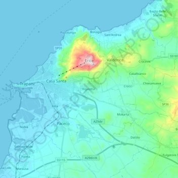
Name: Erice topographic map, elevation, terrain.

Location: Erice, Trapani, Sicily, 91016, Italy (37.95464 12.52894 38.07052 12.73292)

Average elevation: 85 m

Minimum elevation: -2 m

Maximum elevation: 761 m

Other topographic maps

Click on a map to view its topography, its elevation and its terrain.

Alcamo Marina

Italy > Sicily > Trapani > Alcamo

Average elevation: 46 m

Isola Santa Maria

Italy > Sicily > Trapani > Marsala

Average elevation: 1 m

Borgata Costiera

Italy > Sicily > Trapani > Mazara del Vallo

Average elevation: 95 m

Gear up for your next adventure:

🔥Emergency Fire Starter - Reliable ignition source for all weather conditions
👟Trail Running Shoes - Agile footwear for fast-paced topographic exploration
🧥Waterproof Pants - Keep dry during rainy hiking conditions
🧢Outdoor Visor - Breathable visor for sunny hikes
🦯Trekking Poles - Reduced impact on joints for steep topographic climbs

As an Amazon Associate, this site earns from qualifying purchases at no extra cost to you.