Geolocate

Nueiba topographic map

Click on the map to display elevation.

About this map

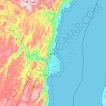
Name: Nueiba topographic map, elevation, terrain.

Location: Nueiba, South Sinai, 46618, Egypt (28.87500 34.50167 29.19500 34.82167)

Average elevation: 279 m

Minimum elevation: -1 m

Maximum elevation: 1,052 m

Other topographic maps

Click on a map to view its topography, its elevation and its terrain.

Abu Galum Protectorate

Egypt > South Sinai

Average elevation: 632 m

Al Tour City

Egypt > South Sinai

Average elevation: 50 m

Ras Muhammad National Park

Egypt > South Sinai

Average elevation: 112 m

Ras Sudr

Egypt > South Sinai

Average elevation: 17 m

Wadi Khuraytah

Egypt > South Sinai > Saint Catherine

Average elevation: 1,323 m

Ras Sudr

Egypt > South Sinai

Average elevation: 17 m

Gear up for your next adventure:

🩹Compact First Aid Kit - Pre-packed essentials for common trail injuries
🚑Survival Whistle - Signal for help across long distances in mountains
🎒Hiking Backpack - Lightweight and ergonomic backpacks for day hikes or multi-day treks
🔋Emergency Crank Radio - Weather alerts and power without needing batteries
🌬️Windproof Camp Stove - Efficient cooking even on exposed mountain peaks

As an Amazon Associate, this site earns from qualifying purchases at no extra cost to you.