Geolocate

Volterra topographic map

Click on the map to display elevation.

About this map

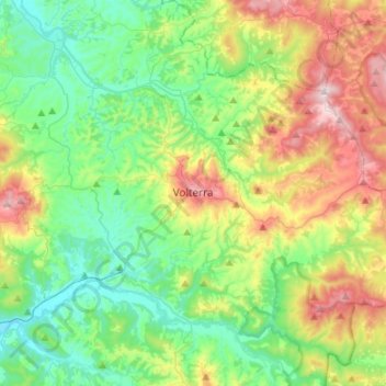
Name: Volterra topographic map, elevation, terrain.

Location: Volterra, Pisa, Tuscany, 56048, Italy (43.30214 10.76978 43.49743 11.01332)

Average elevation: 228 m

Minimum elevation: 44 m

Maximum elevation: 626 m

Other topographic maps

Click on a map to view its topography, its elevation and its terrain.

Collemontanino

Italy > Tuscany > Pisa

Average elevation: 246 m

Gear up for your next adventure:

🧶550 Survival Paracord - Versatile utility cord for emergency repairs and rigging
🥾Lightweight Hiking Shoes - Comfortable shoes for day hikes
💧Hydration Pack - Hands-free hydration system for long hikes
🛶Kayak Dry Bag - Waterproof storage for kayaking adventures
🍽️Titanium Camping Spork - Ultralight and indestructible eating utensil

As an Amazon Associate, this site earns from qualifying purchases at no extra cost to you.