
Make a donation
Gear up for your next adventure:
As an Amazon Associate, this site earns from qualifying purchases at no extra cost to you.
Dannevirke topographic map
Click on the map to display elevation.
Make a donation
Gear up for your next adventure:
As an Amazon Associate, this site earns from qualifying purchases at no extra cost to you.
Dannevirke
Dannevirke has an Oceanic climate, (Köppen:Cfb). Due its high altitude the summer temperatures are often cooler compared to other Eastern North Island towns, such as Masterton, Napier and Gisborne, while in winter Dannevirke can regularly experience frosts as in other parts of New Zealand. Snow is rare, the latest snow to hit Dannevirke was 15 August 2011.
Make a donation
Gear up for your next adventure:
As an Amazon Associate, this site earns from qualifying purchases at no extra cost to you.
About this map
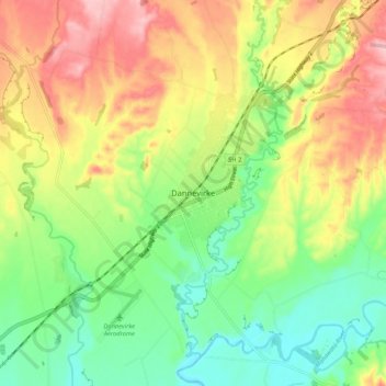
Name: Dannevirke topographic map, elevation, terrain.
Average elevation: 221 m
Minimum elevation: 149 m
Maximum elevation: 314 m
Make a donation
Gear up for your next adventure:
As an Amazon Associate, this site earns from qualifying purchases at no extra cost to you.