Geolocate

Newberry topographic map

Click on the map to display elevation.

About this map
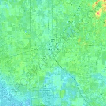
Name: Newberry topographic map, elevation, terrain.

Location: Newberry, Alachua County, Florida, United States (29.53562 -82.65708 29.74198 -82.52381)

Average elevation: 27 m

Minimum elevation: 17 m

Maximum elevation: 60 m

Other topographic maps

Click on a map to view its topography, its elevation and its terrain.
Earleton

United States > Florida > Alachua County

Average elevation: 46 m

Island Grove

United States > Florida > Alachua County

Average elevation: 18 m

Misty Oaks

United States > Florida > Alachua County

Average elevation: 21 m

Archer

United States > Florida > Alachua County > Archer

Average elevation: 25 m

Bland

United States > Florida > Alachua County

Average elevation: 44 m

Gear up for your next adventure:

🕶️Polarized Sunglasses - Protect your eyes with durable polarized lenses
🥾Trail Hiking Shoes - Durable shoes designed for rugged trails
🚲Handlebar Phone Mount - View topographic-map.com live while cycling
🔭Compact Monocular - One-handed bird watching and trail spotting
🧥Packable Rain Jacket - Breathable waterproof layer for unpredictable weather

As an Amazon Associate, this site earns from qualifying purchases at no extra cost to you.