Geolocate

Salemi topographic map

Click on the map to display elevation.

About this map
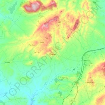
Name: Salemi topographic map, elevation, terrain.

Location: Salemi, Trapani, Sicily, 91018, Italy (37.74333 12.66590 37.90076 12.88136)

Average elevation: 288 m

Minimum elevation: 80 m

Maximum elevation: 748 m

Other topographic maps

Click on a map to view its topography, its elevation and its terrain.

Isola San Pantaleo

Italy > Sicily > Trapani > Marsala

Average elevation: 1 m

Scopello

Italy > Sicily > Trapani > Castellammare del Golfo

Average elevation: 150 m

Segesta

Italy > Sicily > Trapani > Calatafimi Segesta

Average elevation: 269 m

Trapani

Italy > Sicily > Trapani > Trapani

Average elevation: 46 m

Nubia

Italy > Sicily > Trapani > Paceco

Average elevation: 4 m

Mursía

Italy > Sicily > Trapani > Pantelleria

Average elevation: 40 m

Macari

Italy > Sicily > Trapani

Average elevation: 225 m

Isola San Pantaleo

Italy > Sicily > Trapani > Marsala

Average elevation: 1 m

Nubia

Italy > Sicily > Trapani > Paceco

Average elevation: 4 m

Monte Casal Monaco

Italy > Sicily > Trapani > Trapani

Average elevation: 453 m

Gear up for your next adventure:

🔥Camping Stove - Portable stoves to cook outdoors with ease
🥾Lightweight Hiking Shoes - Comfortable shoes for day hikes
🥘Camping Cookware Set - Compact nesting pots and pans for trail cooking
☕Camping Coffee Maker - Brew fresh coffee anywhere on the topographic map
💧Hydration Bladder - Hands-free hydration solution for long treks

As an Amazon Associate, this site earns from qualifying purchases at no extra cost to you.