Geolocate

Ruawai topographic map

Click on the map to display elevation.

About this map
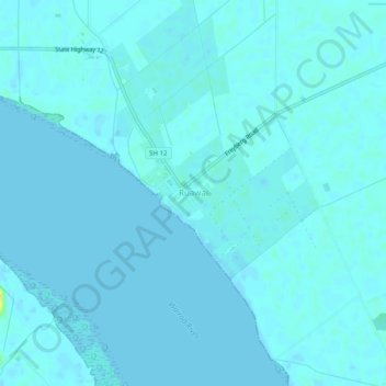
Name: Ruawai topographic map, elevation, terrain.

Location: Ruawai, Kaipara District, Northland, 0530, New Zealand (-36.15687 174.00528 -36.11687 174.04528)

Average elevation: 2 m

Minimum elevation: -1 m

Maximum elevation: 24 m

Other topographic maps

Click on a map to view its topography, its elevation and its terrain.
Wairoa River

New Zealand > Northland > Kaipara District

Average elevation: 42 m

Lake Kaiiwi

New Zealand > Northland > Kaipara District

Average elevation: 79 m

Lake Rototuna

New Zealand > Northland > Kaipara District

Average elevation: 120 m

Wairoa River

New Zealand > Northland > Kaipara District

Average elevation: 42 m

Gear up for your next adventure:

🛰️Satellite Messenger - Emergency communication for areas with no cell service
🧼Travel Hand Sanitizer - Keep hands clean when water is scarce
💧Reusable Water Bottle - Durable water bottles for hydration on trails
🥾Mountain Hiking Shoes - Shoes with superior grip for mountainous terrain
🧥Softshell Hiking Jacket - The perfect balance of wind protection and breathability

As an Amazon Associate, this site earns from qualifying purchases at no extra cost to you.