Geolocate

Aurora topographic map

Click on the map to display elevation.

About this map

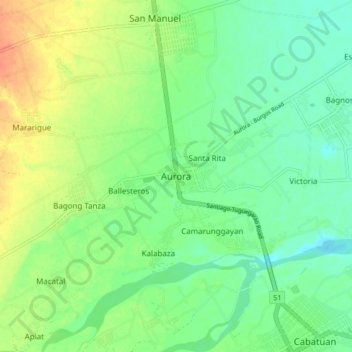
Name: Aurora topographic map, elevation, terrain.

Location: Aurora, Isabela, Cagayan Valley, 3316, Philippines (16.95088 121.59580 17.03088 121.67580)

Average elevation: 62 m

Minimum elevation: 46 m

Maximum elevation: 88 m

Other topographic maps

Click on a map to view its topography, its elevation and its terrain.

San Guillermo

Philippines > Isabela

Average elevation: 92 m

Magat Dam

Philippines > Isabela

Average elevation: 176 m

Gear up for your next adventure:

Lightweight Camping Tent - Portable shelter optimized for Canadian backcountry camping
🧥Thermal Fleece Jacket - Versatile insulation for changing mountain temperatures
🥾Mountain Hiking Shoes - Shoes with superior grip for mountainous terrain
💧Hydration Pack - Hands-free hydration system for long hikes
👖Convertible Hiking Pants - Zip-off legs to adapt to changing weather conditions

As an Amazon Associate, this site earns from qualifying purchases at no extra cost to you.