
Gemeinde Mauerbach topographic map
Click on the map to display elevation.
About this map
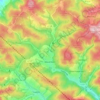
Name: Gemeinde Mauerbach topographic map, elevation, terrain.
Average elevation: 361 m
Minimum elevation: 221 m
Maximum elevation: 505 m
Other topographic maps
Click on a map to view its topography, its elevation and its terrain.
Wöllersdorf
Austria > Lower Austria > Bezirk St. Pölten > Brand-Laaben > Laaben
Average elevation: 518 m
Neusiedl
Austria > Lower Austria > Bezirk St. Pölten > Gemeinde Nußdorf ob der Traisen
Average elevation: 278 m
Ederding
Austria > Lower Austria > Bezirk St. Pölten > Gemeinde Herzogenburg > Ederding
Average elevation: 269 m
Rekawinkel
Austria > Lower Austria > Bezirk St. Pölten > Gemeinde Pressbaum > Rekawinkel
Average elevation: 395 m
Sois
Austria > Lower Austria > Bezirk St. Pölten > Gemeinde Kirchberg an der Pielach > Sois
Average elevation: 494 m