Geolocate

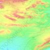
Teri topographic map

Click on the map to display elevation.

About this map

Name: Teri topographic map, elevation, terrain.

Location: Teri, Banda Daud Shah Tehsil, Karak District, Kohat Division, Khyber Pakhtunkhwa, 26390, Pakistan (33.29046 71.08680 33.30905 71.11303)

Average elevation: 637 m

Minimum elevation: 617 m

Maximum elevation: 682 m

Other topographic maps

Click on a map to view its topography, its elevation and its terrain.
Karak

Pakistan > Khyber Pakhtunkhwa > Karak District

Average elevation: 656 m

Gear up for your next adventure:

🧥Softshell Jacket - Windproof and breathable jacket for hiking
🧶550 Survival Paracord - Versatile utility cord for emergency repairs and rigging
📷Outdoor Action Camera - Capture high-elevation views and rugged adventures
🧢Outdoor Cap - Protective cap for sun and rain during hikes
⛺Lightweight Camping Tent - Portable shelter optimized for Canadian backcountry camping

As an Amazon Associate, this site earns from qualifying purchases at no extra cost to you.