Geolocate

Sussex topographic map

Click on the map to display elevation.

About this map

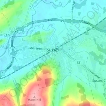
Name: Sussex topographic map, elevation, terrain.

Location: Sussex, Sussex Parish, Kings County, New Brunswick, Canada (45.70790 -65.53728 45.73655 -65.47595)

Average elevation: 38 m

Minimum elevation: 10 m

Maximum elevation: 138 m

Sussex Parish trails, hiking, mountain biking, running and outdoor activities

Other topographic maps

Click on a map to view its topography, its elevation and its terrain.

Jeffries Corner

Canada > New Brunswick > Sussex Parish

Average elevation: 164 m

Ratter Corner

Canada > New Brunswick > Sussex Parish

Average elevation: 147 m

Gear up for your next adventure:

🥾Light Trekking Boots - Supportive boots for multi-day treks
🧢Hiking Sun Hat - Wide-brimmed protection for exposed mountain ridges
🥾Lightweight Hiking Boots - Boots for comfort and mobility on long hikes
🥾Trekking Poles - Adjustable trekking poles to reduce knee stress and improve stability
🎒Fully Waterproof Backpack - Total protection for photography gear and electronics

As an Amazon Associate, this site earns from qualifying purchases at no extra cost to you.