Geolocate

Paud topographic map

Click on the map to display elevation.

About this map
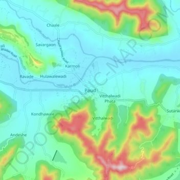
Name: Paud topographic map, elevation, terrain.

Location: Paud, Mulshi Subdistrict, Pune District, Maharashtra, 412108, India (18.48427 73.57551 18.56427 73.65551)

Average elevation: 660 m

Minimum elevation: 561 m

Maximum elevation: 976 m

Other topographic maps

Click on a map to view its topography, its elevation and its terrain.

Temghar dam

India > Maharashtra > Mulshi Subdistrict

Average elevation: 745 m

Mulshi Dam

India > Maharashtra > Mulshi Subdistrict > Sambhave

Average elevation: 608 m

Shirgaon

India > Maharashtra > Mulshi Subdistrict

Average elevation: 688 m

Gear up for your next adventure:

🧳Compression Sacks - Maximize space in your backpack by shrinking gear
☕Camping Coffee Maker - Brew fresh coffee anywhere on the topographic map
❄️Traction Ice Cleats - Slip-on spikes for icy trails and winter hiking
🥾Hiking Leggings - Comfortable leggings for outdoor activities
🦶Hiking Shoe Insoles - Added support for high arches and long days on feet

As an Amazon Associate, this site earns from qualifying purchases at no extra cost to you.