Geolocate

Gadog topographic map

Click on the map to display elevation.

About this map

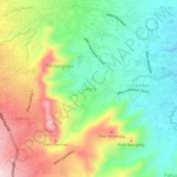
Name: Gadog topographic map, elevation, terrain.

Location: Gadog, Cianjur, West Java, 43253, Indonesia (-6.75217 107.04417 -6.71217 107.08417)

Average elevation: 928 m

Minimum elevation: 782 m

Maximum elevation: 1,147 m

Other topographic maps

Click on a map to view its topography, its elevation and its terrain.

Kertajadi

Indonesia > West Java > Cianjur

Average elevation: 108 m

Agrabinta

Indonesia > West Java > Cianjur

Average elevation: 108 m

Cidaun

Indonesia > West Java > Cianjur

Average elevation: 658 m

Karangwangi

Indonesia > West Java > Cianjur

Average elevation: 119 m

Wanasari

Indonesia > West Java > Cianjur

Average elevation: 31 m

Jayapura

Indonesia > West Java > Cianjur

Average elevation: 73 m

Cisalak

Indonesia > West Java > Cianjur

Average elevation: 49 m

Gear up for your next adventure:

🧴Bear Spray Holster - Quick-access carry for essential Canadian wilderness safety
🧥Packable Rain Jacket - Breathable waterproof layer for unpredictable weather
🧥Waterproof Hiking Jacket - Protect yourself from rain and wind while hiking
🛌Insulated Sleeping Pad - Critical thermal barrier between you and the cold ground
🧥Ultralight Puffy Jacket - Maximum warmth that packs down to the size of an orange

As an Amazon Associate, this site earns from qualifying purchases at no extra cost to you.