Geolocate

Visiano topographic map

Click on the map to display elevation.

About this map
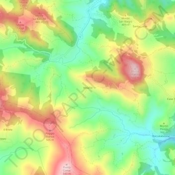
Name: Visiano topographic map, elevation, terrain.

Location: Visiano, Medesano, Parma, Emilia-Romagna, Italia (44.71071 10.00552 44.75071 10.04552)

Average elevation: 357 m

Minimum elevation: 205 m

Maximum elevation: 544 m

Other topographic maps

Click on a map to view its topography, its elevation and its terrain.

Varano de' Melegari

Italia > Emilia-Romagna > Parma

Average elevation: 363 m

Pellegrino Parmense

Italia > Emilia-Romagna > Parma

Average elevation: 432 m

Compiano

Italia > Emilia-Romagna > Parma

Average elevation: 758 m

Fiume Taro

Italia > Emilia-Romagna > Parma > Copezzato

Average elevation: 35 m

Busseto

Italia > Emilia-Romagna > Parma

Average elevation: 47 m

Torrente Baganza

Italia > Emilia-Romagna > Parma > Parma

Average elevation: 114 m

Colorno

Italia > Emilia-Romagna > Parma

Average elevation: 29 m

Soragna

Italia > Emilia-Romagna > Parma

Average elevation: 42 m

Taro

Italia > Emilia-Romagna > Parma > Borgo Val di Taro

Average elevation: 699 m

Gear up for your next adventure:

🧤Rechargeable Heated Gloves - Extreme warmth for Canadian winter expeditions
🐕Hiking Dog Pack - Let your canine companion carry their own water and food
🩹Compact First Aid Kit - Pre-packed essentials for common trail injuries
⛺Family Camping Tent - Spacious tent suitable for family camping trips
🛏️Sleeping Bag - Warm and compact sleeping bags for outdoor camping

As an Amazon Associate, this site earns from qualifying purchases at no extra cost to you.