Geolocate

Panalsalan topographic map

Click on the map to display elevation.

About this map

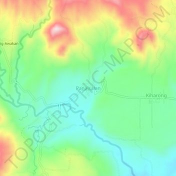
Name: Panalsalan topographic map, elevation, terrain.

Location: Panalsalan, Maramag, Bukidnon, Northern Mindanao, Philippines (7.84083 124.95713 7.88083 124.99713)

Average elevation: 607 m

Minimum elevation: 480 m

Maximum elevation: 824 m

Other topographic maps

Click on a map to view its topography, its elevation and its terrain.

Pulangi Dam

Philippines > Bukidnon > Maramag > Panadtalan

Average elevation: 295 m

Gear up for your next adventure:

🔪Outdoor Multitool - Versatile tool for repairs and food prep in the wild
🛌Down Sleeping Bag - Superior warmth-to-weight ratio for cold nights
🧥Waterproof Jacket - Lightweight rain jackets for hiking and outdoor activities
🥾Waterproof Hiking Shoes - Durable shoes for wet and rugged trails
🎒Backpack Rain Cover - External shield to keep your entire pack dry

As an Amazon Associate, this site earns from qualifying purchases at no extra cost to you.