Geolocate

Teangue topographic map

Click on the map to display elevation.

About this map

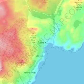
Name: Teangue topographic map, elevation, terrain.

Location: Teangue, Highland, Scotland, IV44 8RD, United Kingdom (57.09216 -5.87757 57.13216 -5.83757)

Average elevation: 81 m

Minimum elevation: 0 m

Maximum elevation: 218 m

Other topographic maps

Click on a map to view its topography, its elevation and its terrain.

Loch Ness

United Kingdom > Scotland > Highland > Dores

Average elevation: 340 m

Strathnairn

United Kingdom > Scotland > Highland > Daviot

Average elevation: 268 m

Whitebridge

United Kingdom > Scotland > Highland

Average elevation: 223 m

Glen Coe

United Kingdom > Scotland > Highland > Glencoe

Average elevation: 414 m

Gear up for your next adventure:

🧼Travel Hand Sanitizer - Keep hands clean when water is scarce
🏕️Camping Hammock - Integrated protection for sleeping between trees
🥫Freeze-Dried Meals - Lightweight, high-calorie nutrition for multi-day treks
🥾Hiking Boots - Sturdy boots providing ankle support and traction on rugged trails
👟Leg Gaiters - Keep debris, mud, and snow out of your boots

As an Amazon Associate, this site earns from qualifying purchases at no extra cost to you.