Geolocate

Pachachaca topographic map

Click on the map to display elevation.

About this map

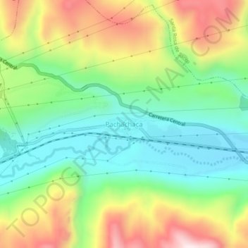
Name: Pachachaca topographic map, elevation, terrain.

Location: Pachachaca, Yauli, Junín, Perú (-11.63856 -76.03956 -11.59856 -75.99956)

Average elevation: 4,182 m

Minimum elevation: 3,941 m

Maximum elevation: 4,562 m

Other topographic maps

Click on a map to view its topography, its elevation and its terrain.

Laguna Pomacocha

Perú > Junín > Yauli > Pomacocha

Average elevation: 4,525 m

Gear up for your next adventure:

🗺️Topographic Maps - Detailed maps to explore trails, mountains, and wilderness areas
🥾Trail Hiking Socks - Comfortable socks to prevent blisters and fatigue
👟Sport Hiking Sandals - Breathable footwear for water crossings and camp rest
🧤Thermal Hiking Gloves - Grip-enhanced gloves for cold-weather altitude trekking
🛁Quick-Dry Microfiber Towel - Space-saving towel that dries rapidly on the move

As an Amazon Associate, this site earns from qualifying purchases at no extra cost to you.