Geolocate

Chumukedima topographic map

Click on the map to display elevation.

About this map

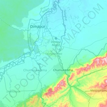
Name: Chumukedima topographic map, elevation, terrain.

Location: Chumukedima, Chümoukedima District, Nagaland, India (25.72120 93.70831 25.97365 93.80693)

Average elevation: 221 m

Minimum elevation: 134 m

Maximum elevation: 772 m

Other topographic maps

Click on a map to view its topography, its elevation and its terrain.

Longkhim

India > Nagaland > Longkhim

Average elevation: 1,627 m

Kohīma

India > Nagaland

Average elevation: 1,001 m

Gear up for your next adventure:

🚲Heavy Duty Bike Lock - Secure your bike at the trailhead or during stops
🧢Hiking Sun Hat - Wide-brimmed protection for exposed mountain ridges
🥾Waterproof Hiking Shoes - Durable shoes for wet and rugged trails
🧢Outdoor Cap - Protective cap for sun and rain during hikes
🧴Sunscreen SPF - Broad-spectrum sunscreen for outdoor activities

As an Amazon Associate, this site earns from qualifying purchases at no extra cost to you.