Geolocate

Pyras topographic map

Click on the map to display elevation.

About this map

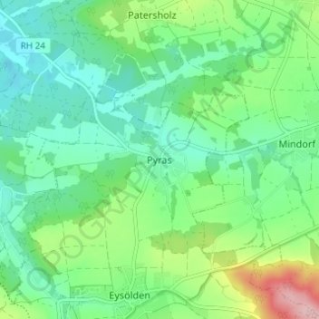
Name: Pyras topographic map, elevation, terrain.

Location: Pyras, Thalmässing, Landkreis Roth, Bayern, 91161, Deutschland (49.12872 11.19779 49.16872 11.23779)

Average elevation: 420 m

Minimum elevation: 371 m

Maximum elevation: 546 m

Other topographic maps

Click on a map to view its topography, its elevation and its terrain.

91177

Deutschland > Bayern > Landkreis Roth > Thalmässing > Stetten

Average elevation: 475 m

Gear up for your next adventure:

🥽Outdoor Goggles - Protective eyewear for outdoor activities
🧦Outdoor Socks - Durable socks designed for hiking and outdoor sports
Camping Groundsheet - Protect your tent from moisture and dirt
🪑Ultralight Camping Stool - Compact seating for rest stops during long hikes
🧼Biodegradable Camp Soap - Environmentally friendly cleaning for gear and body

As an Amazon Associate, this site earns from qualifying purchases at no extra cost to you.