Geolocate

Ilog topographic map

Click on the map to display elevation.

About this map

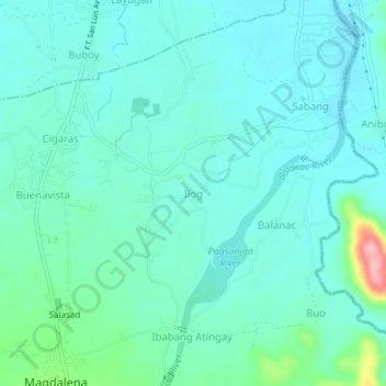
Name: Ilog topographic map, elevation, terrain.

Location: Ilog, Magdalena, Laguna, Calabarzon, 4007, Philippines (14.19922 121.42398 14.23922 121.46398)

Average elevation: 33 m

Minimum elevation: 5 m

Maximum elevation: 165 m

Other topographic maps

Click on a map to view its topography, its elevation and its terrain.

Halayhayin

Philippines > Laguna > Magdalena

Average elevation: 70 m

Tanawan

Philippines > Laguna > Magdalena

Average elevation: 145 m

Gear up for your next adventure:

🧥Packable Rain Jacket - Breathable waterproof layer for unpredictable weather
🚲MTB Frame Bag - Carry tools and maps directly on your bicycle frame
🧳Compression Sacks - Maximize space in your backpack by shrinking gear
🧼Travel Hand Sanitizer - Keep hands clean when water is scarce
💡Portable Camping Lamp - Rechargeable lamp for campsite lighting

As an Amazon Associate, this site earns from qualifying purchases at no extra cost to you.