
Make a donation
Gear up for your next adventure:
As an Amazon Associate, this site earns from qualifying purchases at no extra cost to you.
Sand a. Main topographic map
Click on the map to display elevation.
Make a donation
Gear up for your next adventure:
As an Amazon Associate, this site earns from qualifying purchases at no extra cost to you.
Sand a. Main
Ein traditioneller Zweig der Landwirtschaft, der Weinbau, ist auch heute noch in Sand lebendig. Die ortsansässigen Winzer bauen an den Berghängen rund um das Dorf ihren Wein an. Das sommerliche Altmain-Weinfest ist der Höhepunkt im Veranstaltungsjahr. Mit mittlerweile etwa 50.000 Besuchern an vier Tagen ist es eines der meistbesuchten Feste in der Umgebung. Außerdem betreiben zurzeit etwa acht Sander Winzer eine eigene Heckenwirtschaft.
Make a donation
Gear up for your next adventure:
As an Amazon Associate, this site earns from qualifying purchases at no extra cost to you.
About this map
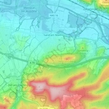
Name: Sand a. Main topographic map, elevation, terrain.
Location: Sand a. Main, Landkreis Haßberge, Bayern, 97522, Deutschland (49.95463 10.56721 50.00476 10.61569)
Average elevation: 283 m
Minimum elevation: 217 m
Maximum elevation: 455 m
Make a donation
Gear up for your next adventure:
As an Amazon Associate, this site earns from qualifying purchases at no extra cost to you.