
Make a donation
Gear up for your next adventure:
As an Amazon Associate, this site earns from qualifying purchases at no extra cost to you.
Fairview topographic map
Click on the map to display elevation.
Make a donation
Gear up for your next adventure:
As an Amazon Associate, this site earns from qualifying purchases at no extra cost to you.
Fairview
The terrain is hilly to gently rolling, with elevations ranging from 200 feet near the Don Castro Regional Recreation Area (a park within the East Bay Regional Park District) to nearly 1,100 feet along Fairview Avenue.
Make a donation
Gear up for your next adventure:
As an Amazon Associate, this site earns from qualifying purchases at no extra cost to you.
About this map
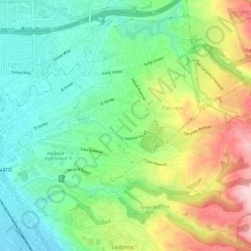
Name: Fairview topographic map, elevation, terrain.
Location: Fairview, Alameda County, California, United States (37.65576 -122.07290 37.69570 -122.02398)
Average elevation: 123 m
Minimum elevation: 19 m
Maximum elevation: 305 m
Make a donation
Gear up for your next adventure:
As an Amazon Associate, this site earns from qualifying purchases at no extra cost to you.