Geolocate

Cahors topographic map

Click on the map to display elevation.

About this map

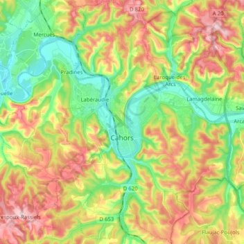
Name: Cahors topographic map, elevation, terrain.

Location: Cahors, Lot, Occitania, Metropolitan France, 46000, France (44.40097 1.37253 44.51212 1.50554)

Average elevation: 207 m

Minimum elevation: 102 m

Maximum elevation: 343 m

Other topographic maps

Click on a map to view its topography, its elevation and its terrain.

Flaujac-Haut

France > Occitania > Lot > Flaujac-Gare

Average elevation: 335 m

Bovila

France > Occitania > Lot > Porte-du-Quercy

Average elevation: 243 m

Labrousse

France > Occitania > Lot > Prayssac

Average elevation: 123 m

Les Vignottes

France > Occitania > Lot > Prendeignes

Average elevation: 373 m

Cournou

France > Occitania > Lot > Saint-Vincent-Rive-d'Olt

Average elevation: 243 m

Les Boules

France > Occitania > Lot > Bellefont-La Rauze

Average elevation: 276 m

Revers

France > Occitania > Lot > Le Vigan-en-Quercy

Average elevation: 262 m

Mas Ponchet

France > Occitania > Lot > Cressensac-Sarrazac

Average elevation: 215 m

Brugales

France > Occitania > Lot > Laval-de-Cère

Average elevation: 311 m

Saint-Esprit

France > Occitania > Lot > Martel

Average elevation: 239 m

Concots

France > Occitania > Lot > Concots > Concots

Average elevation: 268 m

Gear up for your next adventure:

🧥Softshell Hiking Jacket - The perfect balance of wind protection and breathability
👟Sport Hiking Sandals - Breathable footwear for water crossings and camp rest
🦶Anti-Blister Balm - Prevents friction and hotspots during long ascents
🚑Survival Whistle - Signal for help across long distances in mountains
🥾All-Terrain Hiking Boots - Versatile boots for varied hiking conditions

As an Amazon Associate, this site earns from qualifying purchases at no extra cost to you.