
Make a donation
Gear up for your next adventure:
As an Amazon Associate, this site earns from qualifying purchases at no extra cost to you.
La Villedieu topographic map
Click on the map to display elevation.
Make a donation
Gear up for your next adventure:
As an Amazon Associate, this site earns from qualifying purchases at no extra cost to you.
About this map
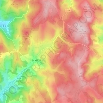
Name: La Villedieu topographic map, elevation, terrain.
Average elevation: 1,380 m
Minimum elevation: 1,192 m
Maximum elevation: 1,501 m
Make a donation
Gear up for your next adventure:
As an Amazon Associate, this site earns from qualifying purchases at no extra cost to you.
Other topographic maps
Click on a map to view its topography, its elevation and its terrain.
Signal de Randon
France > Occitanie > Lozère > Monts-de-Randon
L'étage montagnard supérieur s'étend de 1 250 à 1 450 m et est principalement composé d'une hêtraie d’altitude acidiphile. Au-dessus de 1 450 m, l'étage subalpin présente une lande à callune et myrtille.
Average elevation: 1,454 m
Make a donation
Gear up for your next adventure:
As an Amazon Associate, this site earns from qualifying purchases at no extra cost to you.