
Make a donation
Gear up for your next adventure:
As an Amazon Associate, this site earns from qualifying purchases at no extra cost to you.
Lac Babiche topographic map
Click on the map to display elevation.
Make a donation
Gear up for your next adventure:
As an Amazon Associate, this site earns from qualifying purchases at no extra cost to you.
About this map
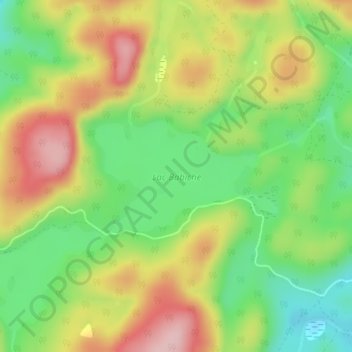
Name: Lac Babiche topographic map, elevation, terrain.
Average elevation: 346 m
Minimum elevation: 254 m
Maximum elevation: 455 m
Make a donation
Gear up for your next adventure:
As an Amazon Associate, this site earns from qualifying purchases at no extra cost to you.
Other topographic maps
Click on a map to view its topography, its elevation and its terrain.
Lac des Trente et un Milles
Canada > Québec > Antoine-Labelle > Notre-Dame-de-Pontmain
Average elevation: 173 m
Make a donation
Gear up for your next adventure:
As an Amazon Associate, this site earns from qualifying purchases at no extra cost to you.
Île à Matha-Constantineau
Canada > Québec > Antoine-Labelle > Notre-Dame-de-Pontmain
Average elevation: 205 m