
Thank you for supporting this site ❤️
Make a donation
Make a donation
Gear up for your next adventure:
As an Amazon Associate, this site earns from qualifying purchases at no extra cost to you.
Chechi topographic map
Click on the map to display elevation.
Thank you for supporting this site ❤️
Make a donation
Make a donation
Gear up for your next adventure:
As an Amazon Associate, this site earns from qualifying purchases at no extra cost to you.
About this map
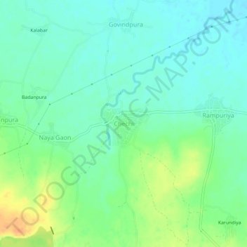
Name: Chechi topographic map, elevation, terrain.
Location: Chechi, Begun Tehsil, Chittorgarh, Rajasthan, Indien (24.94174 75.06932 24.98174 75.10932)
Average elevation: 412 m
Minimum elevation: 399 m
Maximum elevation: 438 m
Thank you for supporting this site ❤️
Make a donation
Make a donation
Gear up for your next adventure:
As an Amazon Associate, this site earns from qualifying purchases at no extra cost to you.