Geolocate

Junrejo topographic map

Click on the map to display elevation.

About this map

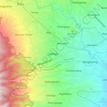
Name: Junrejo topographic map, elevation, terrain.

Location: Junrejo, Batu, Lowokwaru, East Java, Java, 65321, Indonesia (-7.94816 112.51178 -7.86816 112.59178)

Average elevation: 810 m

Minimum elevation: 539 m

Maximum elevation: 1,331 m

Other topographic maps

Click on a map to view its topography, its elevation and its terrain.

Alun-Alun Batu

Indonesia > East Java > Batu > Temas

Average elevation: 892 m

Alun-Alun Batu

Indonesia > East Java > Batu > Temas

Average elevation: 892 m

Gear up for your next adventure:

🧢Outdoor Visor - Breathable visor for sunny hikes
🗺️Topographic Maps - Detailed maps to explore trails, mountains, and wilderness areas
🥾Hiking Leggings - Comfortable leggings for outdoor activities
Camping Groundsheet - Protect your tent from moisture and dirt
💧Reusable Water Bottle - Durable water bottles for hydration on trails

As an Amazon Associate, this site earns from qualifying purchases at no extra cost to you.