
Make a donation
Gear up for your next adventure:
As an Amazon Associate, this site earns from qualifying purchases at no extra cost to you.
Poederlee topographic map
Click on the map to display elevation.
Make a donation
Gear up for your next adventure:
As an Amazon Associate, this site earns from qualifying purchases at no extra cost to you.
Poederlee
Poederlee ligt in de Kempen op een hoogte van 12-19 meter. In het zuiden stroomt de Aa en in het oosten de Laakbeek die zuidwaarts naar de Aa stroomt.
Make a donation
Gear up for your next adventure:
As an Amazon Associate, this site earns from qualifying purchases at no extra cost to you.
About this map
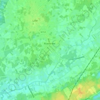
Name: Poederlee topographic map, elevation, terrain.
Location: Poederlee, Lille, Turnhout, Antwerpen, Vlaanderen, België (51.20695 4.79841 51.23989 4.87871)
Average elevation: 14 m
Minimum elevation: 5 m
Maximum elevation: 29 m
Make a donation
Gear up for your next adventure:
As an Amazon Associate, this site earns from qualifying purchases at no extra cost to you.