
Make a donation
Gear up for your next adventure:
As an Amazon Associate, this site earns from qualifying purchases at no extra cost to you.
Izegem topographic map
Click on the map to display elevation.
Make a donation
Gear up for your next adventure:
As an Amazon Associate, this site earns from qualifying purchases at no extra cost to you.
Izegem
Izegem ligt in Zandlemig Vlaanderen en de hoogte varieert van 13,5 tot 30,5 meter. In het noorden stroomt de Mandel, welke in 1979 werd overkluisd. Ook vindt men daar het Kanaal Roeselare-Leie. Het gebied is sterk bebouwd en geïndustrialiseerd en sluit in het westen via Rumbeke aan op de agglomeratie van Roeselare. In oostelijke richting is de plaats vastgegroeid aan de bebouwing van Ingelmunster.
Make a donation
Gear up for your next adventure:
As an Amazon Associate, this site earns from qualifying purchases at no extra cost to you.
About this map
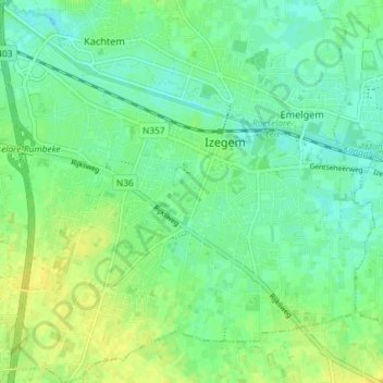
Name: Izegem topographic map, elevation, terrain.
Location: Izegem, Roeselare, West-Vlaanderen, 8870, België (50.89080 3.17247 50.93688 3.24405)
Average elevation: 20 m
Minimum elevation: 11 m
Maximum elevation: 31 m
Make a donation
Gear up for your next adventure:
As an Amazon Associate, this site earns from qualifying purchases at no extra cost to you.
Other topographic maps
Click on a map to view its topography, its elevation and its terrain.