
Thank you for supporting this site ❤️
Make a donation
Make a donation
Gear up for your next adventure:
As an Amazon Associate, this site earns from qualifying purchases at no extra cost to you.
Seyne-les-Alpes topographic map
Click on the map to display elevation.
Thank you for supporting this site ❤️
Make a donation
Make a donation
Gear up for your next adventure:
As an Amazon Associate, this site earns from qualifying purchases at no extra cost to you.
Seyne-les-Alpes
Le village est situé à 1 260 m d’altitude. Les fonds de vallée aux sols profonds et coupés de haies dans la vallée de Seyne sont surnommés « la Suisse provençale ».
Thank you for supporting this site ❤️
Make a donation
Make a donation
Gear up for your next adventure:
As an Amazon Associate, this site earns from qualifying purchases at no extra cost to you.
About this map
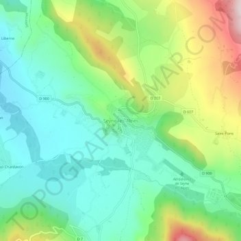
Name: Seyne-les-Alpes topographic map, elevation, terrain.
Average elevation: 1,253 m
Minimum elevation: 1,089 m
Maximum elevation: 1,605 m
Thank you for supporting this site ❤️
Make a donation
Make a donation
Gear up for your next adventure:
As an Amazon Associate, this site earns from qualifying purchases at no extra cost to you.