Geolocate

Robatal topographic map

Click on the map to display elevation.

About this map

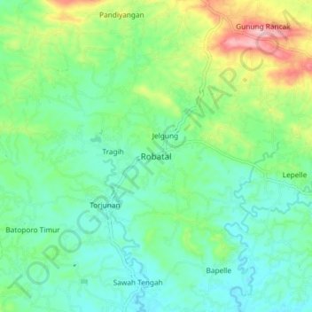
Name: Robatal topographic map, elevation, terrain.

Location: Robatal, Sampang, East Java, Java, Indonesia (-7.04180 113.23884 -6.96180 113.31884)

Average elevation: 92 m

Minimum elevation: 35 m

Maximum elevation: 236 m

Gear up for your next adventure:

🧭GPS Handheld Device - Reliable GPS navigation for outdoor adventures
🥾Trail Running Shoes - Lightweight and durable shoes for trail running
Backpacking Tent - Lightweight tent for long-distance hiking trips
🥾Hiking Boots - Sturdy boots providing ankle support and traction on rugged trails
🧴Waterproofing Spray - Restore the DWR coating on jackets and tents

As an Amazon Associate, this site earns from qualifying purchases at no extra cost to you.