
Thank you for supporting this site ❤️
Make a donation
Make a donation
Gear up for your next adventure:
As an Amazon Associate, this site earns from qualifying purchases at no extra cost to you.
Karaca topographic map
Click on the map to display elevation.
Thank you for supporting this site ❤️
Make a donation
Make a donation
Gear up for your next adventure:
As an Amazon Associate, this site earns from qualifying purchases at no extra cost to you.
About this map
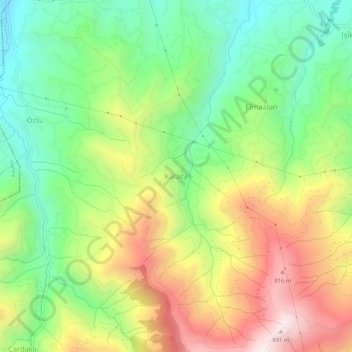
Name: Karaca topographic map, elevation, terrain.
Location: Karaca, Arsin, Trabzon, Région de la mer Noire, Turquie (40.88374 39.90738 40.92374 39.94738)
Average elevation: 432 m
Minimum elevation: 90 m
Maximum elevation: 907 m
Thank you for supporting this site ❤️
Make a donation
Make a donation
Gear up for your next adventure:
As an Amazon Associate, this site earns from qualifying purchases at no extra cost to you.