Geolocate

Maro Sebo topographic map

Click on the map to display elevation.

About this map

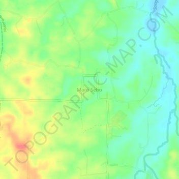
Name: Maro Sebo topographic map, elevation, terrain.

Location: Maro Sebo, Muaro Jambi, Jambi, Sumatra, Indonesia (-1.69643 103.41861 -1.65643 103.45861)

Average elevation: 31 m

Minimum elevation: 8 m

Maximum elevation: 65 m

Other topographic maps

Click on a map to view its topography, its elevation and its terrain.

Telago Rajo

Indonesia > Jambi > Muaro Jambi > Desa Muaro Jambi

Average elevation: 8 m

Sungai Bahar

Indonesia > Jambi > Muaro Jambi

Average elevation: 33 m

Gear up for your next adventure:

🌡️Emergency Mylar Blankets - Compact thermal protection for unexpected nights outdoors
💧Collapsible Water Bottle - Space-saving water bottle for outdoor activities
❄️Traction Ice Cleats - Slip-on spikes for icy trails and winter hiking
🧢Beanie Hat - Keep your head warm in cold weather
🗺️Topographic Maps - Detailed maps to explore trails, mountains, and wilderness areas

As an Amazon Associate, this site earns from qualifying purchases at no extra cost to you.