
Make a donation
Gear up for your next adventure:
As an Amazon Associate, this site earns from qualifying purchases at no extra cost to you.
Roubaix topographic map
Click on the map to display elevation.
Make a donation
Gear up for your next adventure:
As an Amazon Associate, this site earns from qualifying purchases at no extra cost to you.
Roubaix
The land upon which Roubaix stands belongs to the plain of Flanders. The Roubaisian area stretches on an east-west oriented shallow syncline axis which trends south-southeast to the Paleozoic limestone of the Mélantois-Tournaisis faulted anticline. It consists predominantly of Holocene alluvial sediment depositions. It is flat and low, with an elevation drop of only 35 m (114 ft 10 in) over its 13.23 square kilometres (5.11 sq mi). The lowest altitude of this area stands at 17 m (55 ft 9+1⁄2 in), while its highest altitude is 52 m (170 ft 7 in) meters above the sea level.
Make a donation
Gear up for your next adventure:
As an Amazon Associate, this site earns from qualifying purchases at no extra cost to you.
About this map
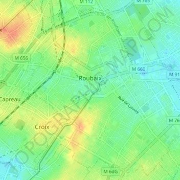
Name: Roubaix topographic map, elevation, terrain.
Average elevation: 37 m
Minimum elevation: 21 m
Maximum elevation: 62 m
Make a donation
Gear up for your next adventure:
As an Amazon Associate, this site earns from qualifying purchases at no extra cost to you.
Other topographic maps
Click on a map to view its topography, its elevation and its terrain.
Make a donation
Gear up for your next adventure:
As an Amazon Associate, this site earns from qualifying purchases at no extra cost to you.
Make a donation
Gear up for your next adventure:
As an Amazon Associate, this site earns from qualifying purchases at no extra cost to you.