Geolocate

Porvenir topographic map

Click on the map to display elevation.

About this map

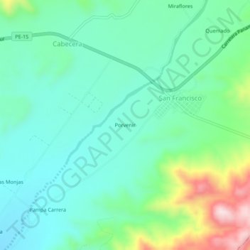
Name: Porvenir topographic map, elevation, terrain.

Location: Porvenir, San Francisco, Santa Cruz, Palpa, Ica, Perú (-14.52915 -75.28338 -14.48915 -75.24338)

Average elevation: 535 m

Minimum elevation: 434 m

Maximum elevation: 828 m

Gear up for your next adventure:

❄️Traction Ice Cleats - Slip-on spikes for icy trails and winter hiking
🧣Merino Neck Gaiter - Protects against wind, sun, and cold at high altitudes
🍽️Titanium Camping Spork - Ultralight and indestructible eating utensil
🧴Insect Repellent - Protect yourself from bugs during outdoor adventures
🛰️Satellite Messenger - Emergency communication for areas with no cell service

As an Amazon Associate, this site earns from qualifying purchases at no extra cost to you.