
Make a donation
Gear up for your next adventure:
As an Amazon Associate, this site earns from qualifying purchases at no extra cost to you.
Wichelen topographic map
Click on the map to display elevation.
Make a donation
Gear up for your next adventure:
As an Amazon Associate, this site earns from qualifying purchases at no extra cost to you.
Wichelen
Wichelen ligt op de linkeroever van de Schelde. De hoogte bedraagt ongeveer 3 meter en de bodem is zandig en in het zuiden zandlemig. Het belangrijkste natuurgebied is de Bergenmeersen, gelegen in een bocht van de Schelde. Ten westen van Wichelen mondt de Molenbeek uit in de Schelde.
Make a donation
Gear up for your next adventure:
As an Amazon Associate, this site earns from qualifying purchases at no extra cost to you.
About this map
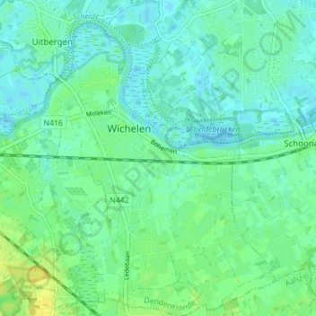
Name: Wichelen topographic map, elevation, terrain.
Location: Wichelen, Dendermonde, Oost-Vlaanderen, 9360, België (50.98026 3.95630 51.02379 4.00634)
Average elevation: 7 m
Minimum elevation: -4 m
Maximum elevation: 20 m
Make a donation
Gear up for your next adventure:
As an Amazon Associate, this site earns from qualifying purchases at no extra cost to you.
Other topographic maps
Click on a map to view its topography, its elevation and its terrain.