
Thank you for supporting this site ❤️
Make a donation
Make a donation
Gear up for your next adventure:
As an Amazon Associate, this site earns from qualifying purchases at no extra cost to you.
Escazú topographic map
Click on the map to display elevation.
Thank you for supporting this site ❤️
Make a donation
Make a donation
Gear up for your next adventure:
As an Amazon Associate, this site earns from qualifying purchases at no extra cost to you.
Escazú
Escazú has an area of 34.49 km² and a mean elevation of 1,129 metres.
Thank you for supporting this site ❤️
Make a donation
Make a donation
Gear up for your next adventure:
As an Amazon Associate, this site earns from qualifying purchases at no extra cost to you.
About this map
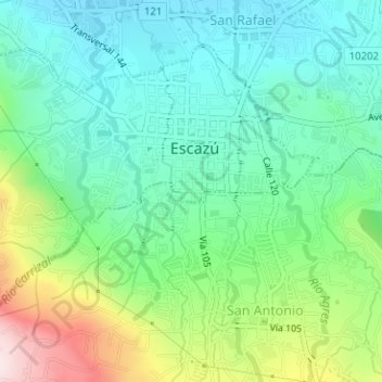
Name: Escazú topographic map, elevation, terrain.
Location: Escazú, Cantón Escazú, San Jose Province, 10201, Costa Rica (9.90482 -84.16286 9.92790 -84.13011)
Average elevation: 1,170 m
Minimum elevation: 1,021 m
Maximum elevation: 1,520 m
Thank you for supporting this site ❤️
Make a donation
Make a donation
Gear up for your next adventure:
As an Amazon Associate, this site earns from qualifying purchases at no extra cost to you.