Geolocate

Hobart topographic map

Click on the map to display elevation.

About this map

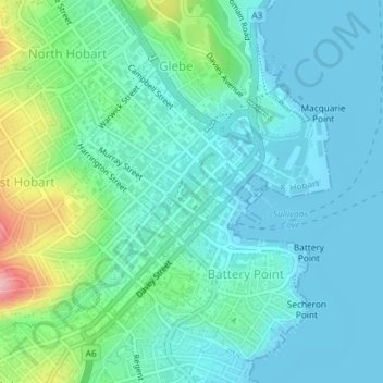
Name: Hobart topographic map, elevation, terrain.

Location: Hobart, Tasmania, Australia (-42.89168 147.31562 -42.87323 147.34151)

Average elevation: 31 m

Minimum elevation: -2 m

Maximum elevation: 147 m

Other topographic maps

Click on a map to view its topography, its elevation and its terrain.

Snug Falls

Australia > Tasmania > Hobart > Snug

Average elevation: 336 m

Knocklofty

Australia > Tasmania > Hobart

Average elevation: 185 m

Glebe Hill

Australia > Tasmania > Hobart

Average elevation: 66 m

Mount Direction

Australia > Tasmania > Hobart

Average elevation: 166 m

Waterworks Reserve

Australia > Tasmania > Hobart

Average elevation: 240 m

Selfs Point

Australia > Tasmania > Hobart

Average elevation: 17 m

Cartwright Point

Australia > Tasmania > Hobart

Average elevation: 59 m

James Austin Park

Australia > Tasmania > Hobart

Average elevation: 25 m

Perrins Ridge

Australia > Tasmania > Hobart

Average elevation: 467 m

Franklin Square

Australia > Tasmania > Hobart

Average elevation: 25 m

Glenrose Park

Australia > Tasmania > Hobart

Average elevation: 181 m

Gear up for your next adventure:

🥾Trekking Boots - Durable boots for long-distance trekking
🥾All-Terrain Hiking Boots - Versatile boots for varied hiking conditions
💡Compact LED Flashlight - Powerful and portable flashlight for outdoor use
🕯️Camping Lantern - Illuminates your entire campsite with high-efficiency LEDs
🥾Approach Boots - Comfortable boots for hiking and climbing approaches

As an Amazon Associate, this site earns from qualifying purchases at no extra cost to you.