Geolocate

Laughlin topographic map

Click on the map to display elevation.

About this map

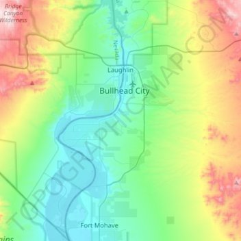
Name: Laughlin topographic map, elevation, terrain.

Location: Laughlin, Clark County, Nevada, USA (35.03573 -114.85324 35.20171 -114.56933)

Average elevation: 403 m

Minimum elevation: 145 m

Maximum elevation: 1,055 m

Gear up for your next adventure:

🥾Hiking Boots - Sturdy boots providing ankle support and traction on rugged trails
🪑Insulated Seat Pad - Protect your seat from cold rocks and wet logs
🔋Lithium AA Batteries - Long-lasting power that performs in extreme cold
🥾Trail Running Boots - Durable shoes designed for trail running
🥾Mountain Trail Shoes - High-traction shoes for mountain trails

As an Amazon Associate, this site earns from qualifying purchases at no extra cost to you.