Geolocate

Pagosa Springs topographic map

Click on the map to display elevation.

About this map

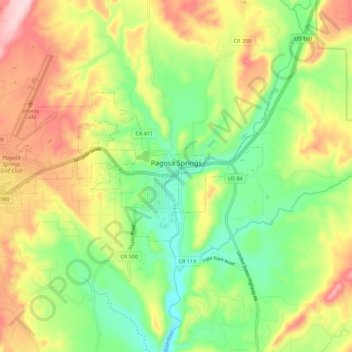
Name: Pagosa Springs topographic map, elevation, terrain.

Location: Pagosa Springs, Archuleta County, Colorado, 81157, United States (37.24491 -107.09506 37.28737 -106.98339)

Average elevation: 2,244 m

Minimum elevation: 2,117 m

Maximum elevation: 2,413 m

Other topographic maps

Click on a map to view its topography, its elevation and its terrain.

Snow Creek

United States > Colorado > Archuleta County

Average elevation: 2,304 m

Gear up for your next adventure:

🦶Hiking Shoe Insoles - Added support for high arches and long days on feet
🥾Hiking Gaiters - Protect legs and shoes from mud, snow, and debris
🛶Canoe Life Vest - Safety vest for water sports
🧦Merino Wool Socks - Moisture-wicking comfort for long-distance hiking
🧢Hiking Hat - Sun-protective and breathable hats for long treks

As an Amazon Associate, this site earns from qualifying purchases at no extra cost to you.