Geolocate

Duitama topographic map

Click on the map to display elevation.

About this map

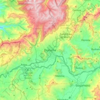
Name: Duitama topographic map, elevation, terrain.

Location: Duitama, Cabecera Municipal Duitama, Duitama, Tundama, Boyacá, RAP (Especial) Central, 150461, Colombia (5.66771 -73.19389 5.98771 -72.87389)

Average elevation: 2,859 m

Minimum elevation: 2,245 m

Maximum elevation: 4,030 m

Other topographic maps

Click on a map to view its topography, its elevation and its terrain.

Río Chicamocha

Colombia > Boyacá > Duitama

Average elevation: 2,734 m

Vereda El Carmen

Colombia > Boyacá > Duitama

Average elevation: 3,356 m

Vereda Santa Helena

Colombia > Boyacá > Duitama

Average elevation: 2,967 m

Río Surba

Colombia > Boyacá > Duitama > Vereda Santa Ana

Average elevation: 3,097 m

Vereda San Antonio Norte

Colombia > Boyacá > Duitama

Average elevation: 3,125 m

Gear up for your next adventure:

🎒Hiking Daypack - Lightweight and durable backpacks for day trips and excursions
🧢Sun Hat - Wide-brim hat for sun protection
Camping Tent - Weather-resistant tents suitable for 2 to 6 people
🧣Merino Neck Gaiter - Protects against wind, sun, and cold at high altitudes
🪑Insulated Seat Pad - Protect your seat from cold rocks and wet logs

As an Amazon Associate, this site earns from qualifying purchases at no extra cost to you.