
Make a donation
Gear up for your next adventure:
As an Amazon Associate, this site earns from qualifying purchases at no extra cost to you.
Boissy-Saint-Léger topographic map
Click on the map to display elevation.
Make a donation
Gear up for your next adventure:
As an Amazon Associate, this site earns from qualifying purchases at no extra cost to you.
About this map
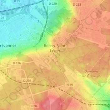
Name: Boissy-Saint-Léger topographic map, elevation, terrain.
Average elevation: 80 m
Minimum elevation: 37 m
Maximum elevation: 113 m
Make a donation
Gear up for your next adventure:
As an Amazon Associate, this site earns from qualifying purchases at no extra cost to you.
Other topographic maps
Click on a map to view its topography, its elevation and its terrain.
Villeneuve-le-Roi
France > Île-de-France > Val-de-Marne > Villeneuve-le-Roi > Villeneuve-le-Roi
Average elevation: 62 m
Make a donation
Gear up for your next adventure:
As an Amazon Associate, this site earns from qualifying purchases at no extra cost to you.
Fort de Champigny
France > Île-de-France > Val-de-Marne > Chennevières-sur-Marne
Average elevation: 85 m
Parc départemental de la Roseraie
France > Île-de-France > Val-de-Marne > L'Haÿ-les-Roses
Average elevation: 76 m
Make a donation
Gear up for your next adventure:
As an Amazon Associate, this site earns from qualifying purchases at no extra cost to you.
Parc Départemental des Hautes Bruyères
France > Île-de-France > Val-de-Marne > Villejuif
Average elevation: 90 m
Villiers-sur-Marne
France > Île-de-France > Val-de-Marne > Villiers-sur-Marne > Villiers-sur-Marne
Average elevation: 73 m
Bry-sur-Marne
France > Île-de-France > Val-de-Marne > Bry-sur-Marne > Bry-sur-Marne
Average elevation: 69 m
Make a donation
Gear up for your next adventure:
As an Amazon Associate, this site earns from qualifying purchases at no extra cost to you.
Mandres-les-Roses
France > Île-de-France > Val-de-Marne > Mandres-les-Roses > Mandres-les-Roses
Mandres-les-Roses est distante de Paris d'environ 25 km, au sud-est de la capitale. Géographiquement, elle appartient au plateau de Brie, vaste plateau bordé par la Marne et la Seine, la côte d'Île-de-France entre Reims et Nogent-sur-Seine, et le rebord oriental du bassin de Paris. C'est une commune dont…
Average elevation: 80 m
Make a donation
Gear up for your next adventure:
As an Amazon Associate, this site earns from qualifying purchases at no extra cost to you.