
Stockton topographic map
Click on the map to display elevation.
About this map
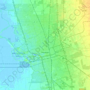
Name: Stockton topographic map, elevation, terrain.
Location: Stockton, San Joaquin County, California, United States (37.88775 -121.41974 38.05830 -121.18404)
Average elevation: 7 m
Minimum elevation: -7 m
Maximum elevation: 23 m
Other topographic maps
Click on a map to view its topography, its elevation and its terrain.
Shumway Oak Grove Regional Park
United States > California > San Joaquin County > Stockton
Average elevation: 3 m
River Islands
United States > California > San Joaquin County > Lathrop > River Islands
Average elevation: 4 m
Lodi
United States > California > San Joaquin County
Lodi is flat terrain at an elevation of approximately 50 feet (15 m) above mean sea level datum. Historically, land in the area has been used for grazing as well as for grain production.
Average elevation: 3 m